Buying a home is one of the biggest investments you’ll make. A land survey helps protect that investment by confirming property boundaries and identifying potential issues before they become costly problems.
What is an SLR?
Old surveys, fences and trees, or even the previous landowners’ assurance do not secure property, only a land survey and title insurance can do that. A land survey – and particularly a surveyor location report (SLR) for residential real estate transactions in Indiana – is a detailed map or drawing of a property that shows its boundaries per a provided legal description, location of buildings and improvements, and other relevant features.
Understanding the Parts of a SLR
A SLR includes an illustrated map of the property detailing the property’s various structures and their relation to the property’s boundaries. The illustrated map includes a variety of features that, once you understand them, will make reading the land survey much easier.
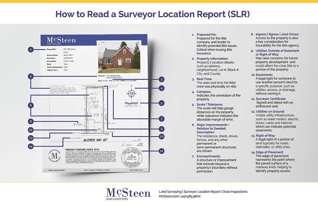
- Property Information – The property’s location, including address, neighborhood, Lot #, Block #, City, and County will be included.
- Compass – Shows the direction the property is facing on the survey. North will always be indicated on the compass.
- Scale – The scale will help you gauge distances on the property in question, including distances between it and nearby landmarks.
- Property Boundaries – Most SLRs will indicate property lines with an actual line, sometimes labeled with angles and measurements so you can figure out the shape and size of the parcel being transferred as described in the legal description included in the deed.
- Important Structures – Key features to note include the residence, sheds, drives, fences, and any other permanent or semi-permanent structures.
- Easements – Easements give a third party, such as companies or government organizations, legal rights to use your property for a specific reason.
- Notes and Exceptions – Any notes or exceptions affecting the property will be included.
- Surveyor’s Certificate – The surveyor’s certificate should be signed and dated with an embossed seal. This certificate provides a legal foundation for the survey’s validity.
With 50+ years of experience in surveying in all 88 counties of Ohio and our expanded service area in 24 counties in Indiana, McSteen is a leader in the industry. Contact us for more information about land surveys or Get a Free Quote and let our team of survey professionals take care of your surveying needs.