Land Surveying Equipment We Use
Our Technology
A core focus at McSteen is to be on the cutting edge of innovation. Our employees are our greatest asset, and we seek to equip them with the latest technology to allow them to do their job with speed and accuracy, while maintaining our quality standards. We love being at the forefront of testing new technology, and continually adding to our arsenal of technology. Here are some of our favorites that help us to provide efficient, precise land surveying services for our clients.
Trimble S6 Robotic Total Station
The Trimble S6 Total Station enables surveyors to remotely see and measure through a live video feed from the tool on their data control. The Trimble S6 Robotic redefines surveying tool performance with an unsurpassed integration of servos, angle sensors, and measurement technology.
Carlson Survey Drafting Software
Users are able to work seamlessly between the office and the field by utilizing company-wide design styles for ease of use and efficiency with Carlson Survey Drafting Software. The software is designed to complement land surveying operations and provides a variety of survey features to process data.
Spectra SP80 RTK GPS
The SP80 is a new generation GNSS receiver that uses the unique Z-Blade technology to track and process all available GNSS signals, providing the most reliable measurements and the highest possible accuracies in challenging environments. The receiver is a powerful, rugged and easy-to-use system designed for everyday surveyors.
Emlid Reach RS2 RTK GPS
A multi-band RTK GNSS receiver, the Emlid Reach RS2 RTK GPS offers centimeter precision for surveying, mapping, and navigation. With a mobile app for added convenience, the Emlid Reach RS2 gets a fixed solution in just seconds and maintains robust performance even in challenging conditions.
Trimble Access Software
The leading field software in land surveying, Trimble Access Software is used along with the Trimble TSC3 Data to support the everyday work of our crews. The technology allows us to improve functionality by offering a familiar interface that increases productivity cost effectively.
Pix4d and Pix4d Survey
A unique photogrammetry software suite for drone mapping that measures from images. This is the next generation photogrammetry software for large scale and corridor mapping, allowing us to make better decisions with accurate 3D maps and models.
Apple iPad with Joy Factory Case
The aXtion Bold MPS for iPad 9.7″ combines the protection of a rugged case with a slim and professional design. The case is built with high quality silicone material that increases the case’s longevity and features a locking mechanism to keep your tablet investment safe. For the mobile workforce, it features a rotating hand strap and a multi-angle stand for portrait and landscape viewing and typing modes.
Trimble TSC3 Data
The Trimble TSC3 Controller is a handheld field computing solution that streamlines the flow of everyday surveying work and devices in the field. A durable device for site measurement, stakeout, and grade checking operations, the TSC3 gives supervisors, foremen, grade checkers, and site engineers total control of site operations.
Trimble R6 RTK GPS
More than a receiver, the Trimble R6 GPS System comprises four integrated parts to deliver maximum accuracy and reliability with GPS. The Trimble R6 GPS System can be integrated with other surveying systems on a job site for superior flexibility.
Phantom 4 Pro
The Phantom 4 Pro drone features quieter flight and an updated transmission system, along with Advanced sensors and processors ensure everything is captured with more image detail and the image data needed for advanced post-production use.
Trimble Business Center
The Trimble Business Center offers field-to-finish survey CAD software that helps surveyors deliver high-accuracy GNSS data, create CAD deliverables, and leverage full data traceability throughout a project’s lifecycle.
Topcon GTS 235w Total Station
The first electronic total station to feature wireless operation, offering four levels of angular accuracy to suit any application. The rugged, waterproof/dustproof design stands up to the harshest construction site environment.
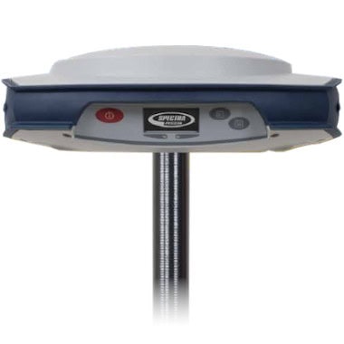
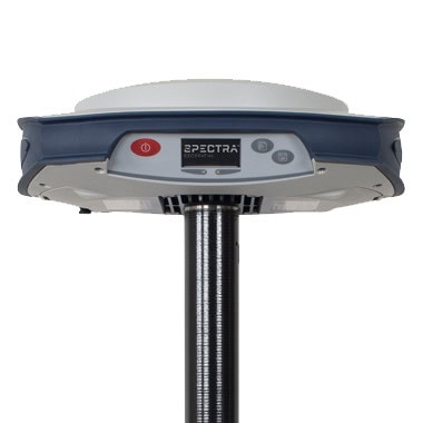
Spectra SP85 RTK GPS
The Spectra Geospatial® SP85 is a next generation GNSS receiver that combines decades of GNSS RTK technology with revolutionary new GNSS processing. Its powerful capabilities, packaged in an ultra-rugged housing and patented antenna design, make SP85 an extremely versatile turnkey solution that can be used with unlimited operation time because of the SP85’s hot-swappable, dual battery setup.
Learn More
For more information on our approach to technology at McSteen, please read Gaining Back One Of Our Most Valuable Resources – Time or our conversation with McSteen CEO, Kevin Woeste, Spotlight on Technology.