
A Practical Guide for Title Professionals, Lenders, and Commercial Real Estate Teams
When a commercial real estate transaction depends on confidence, an ALTA/NSPS Land Title Survey becomes one of the most important documents on the closing table.
An ALTA survey is designed to work alongside the title commitment. It identifies easements, encroachments, improvements, access issues, and other matters that may affect ownership, financing, or title insurance. Because it reviews and addresses Schedule B title exceptions, it provides the information title companies and lenders need to issue extended title coverage with greater confidence.
At first glance, these surveys can appear overwhelming. Between the legal descriptions, title exceptions, boundary information, and technical notes, it’s easy to miss details that could affect underwriting, financing, or the closing itself.
That’s why we created our most recent infographic, How to Read an ALTA/NSPS Land Title Survey. Our goal is simple. It helps title professionals, lenders, attorneys, developers, and property owners better understand what they’re looking at and why each section matters.
What is an ALTA Survey?
An ALTA survey is the national standard for commercial real estate transactions. Prepared by a licensed professional surveyor, it combines field observations, recorded property information, and title commitment data into a single document that provides a comprehensive view of the property.
Unlike surveys prepared solely to establish property boundaries, an ALTA survey is intended to identify matters that could affect title, financing, development, or ownership rights. This includes:
- Boundary information
- Easements
- Rights-of-way
- Improvements
- Encroachments
- Flood zone information
- Optional Table A items requested by the client
Because of its scope, ALTA surveys are frequently required for commercial purchases, refinancing, development projects, and lender underwriting.
ALTA surveys can range from a single page to multiple pages. This multi-page example highlights a wide range of common elements found in commercial transactions, making it a valuable resource for understanding the inner workings of even the most complex ALTA surveys.
Page 1: The Cover Sheet Sets the Foundation
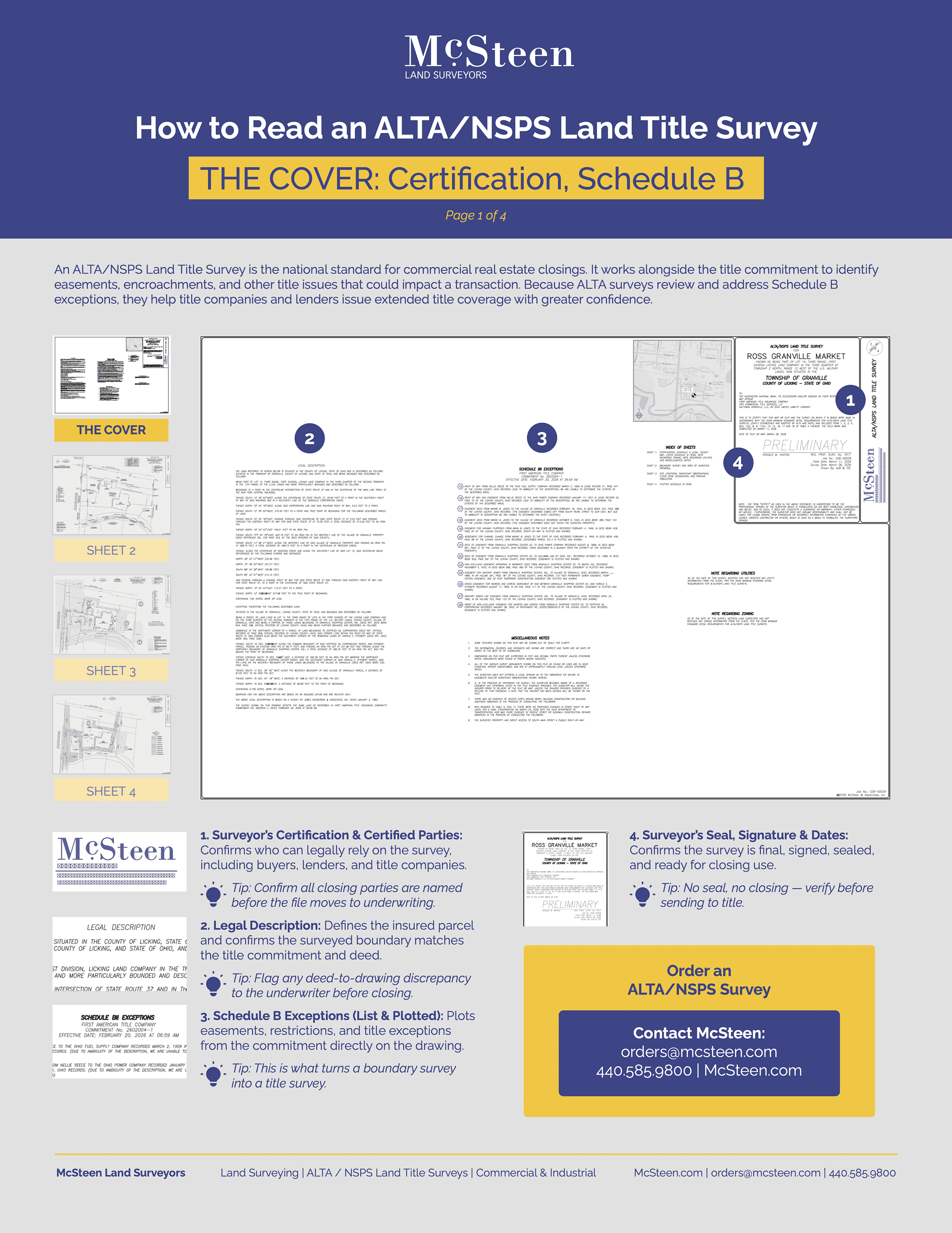
The cover sheet provides much more than administrative information. It establishes exactly what property was surveyed, who may rely upon the survey, and what title matters were reviewed.
Some of the most important items include:
Surveyor’s Certification
The certification identifies the parties who may legally rely on the survey—including buyers, lenders, and title companies.
Before underwriting, verify that every required party is listed.
Legal Description
The legal description should match both the deed and the title commitment.
Any discrepancy between the legal description and the survey drawing deserves immediate attention before closing.
Schedule B Exceptions
One of the defining characteristics of an ALTA survey is that Schedule B title exceptions are reviewed and plotted directly on the survey whenever applicable.
This is what transforms a boundary survey into a true title survey.
Table A Items
Table A contains optional items requested by the client, such as:
- Zoning information
- Parking counts
- Utility information
- Flood data
These optional items should always match the needs of the transaction.
Area Calculation
The survey lists both acreage and square footage, allowing the surveyed parcel to be compared against purchase agreements and recorded documents.
Surveyor’s Seal
A signed and sealed survey confirms the document is complete and ready for transaction use.
Page 2: Understanding the Boundary Drawing
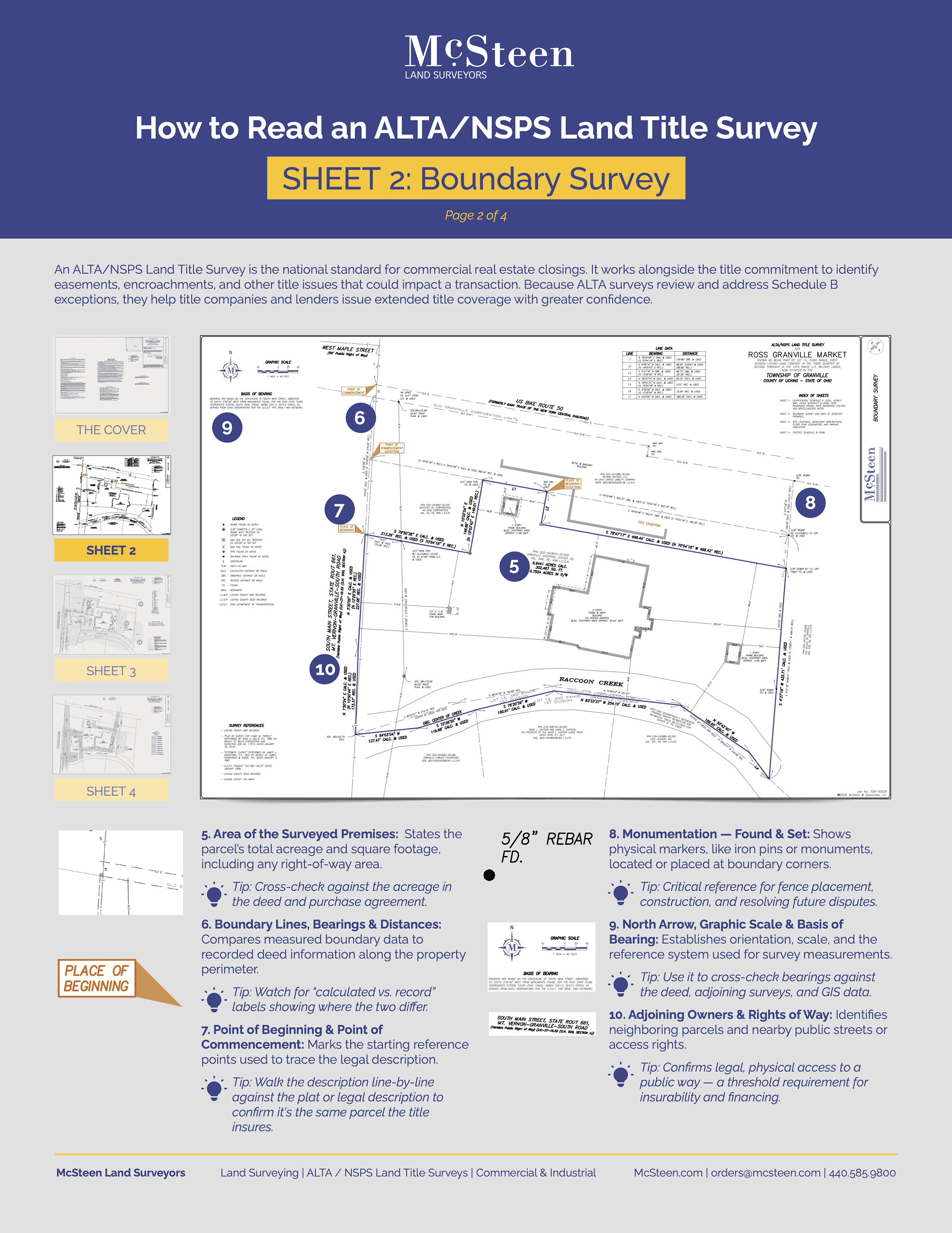
The second sheet on our multipage example contains what many people think of as “the survey.” This drawing illustrates how the surveyor located and calculated the property lines on the ground.
Boundary Lines, Bearings, and Distances
These measurements compare field observations against recorded deed information.
Differences between calculated and recorded values may warrant additional review.
Point of Beginning
The Point of Beginning and Point of Commencement establish the legal starting references used to describe the parcel.
For title professionals, confirming these points helps ensure the survey matches the property described in the title commitment.
Monumentation
Survey monuments—including iron pins and other markers—show where property corners were found or set.
These markers become valuable references for future improvements, construction, or boundary questions.
North Arrow and Basis of Bearing
These establish the orientation and measurement system used throughout the survey.
Adjoining Owners and Rights-of-Way
Nearby parcels, streets, and access rights are identified to verify legal access—a key consideration for financing and title insurance.
Page 3: Improvements, Encroachments, and Flood Information
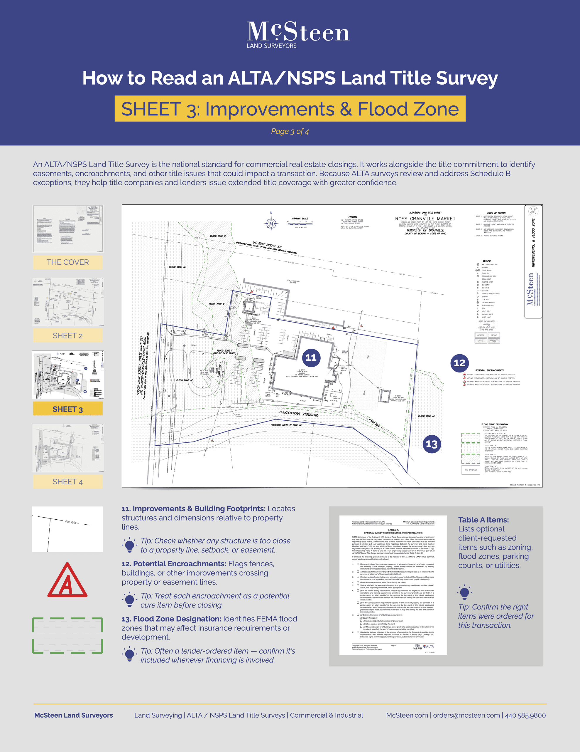
This portion of the survey often receives significant attention during underwriting because it illustrates how improvements relate to the property’s legal boundaries.
Building Footprints
Structures are located relative to property lines, making it easy to identify potential setback concerns.
Potential Encroachments
The survey identifies situations where improvements may cross:
- Property lines
- Easement boundaries
- Neighboring parcels
Even a seemingly minor encroachment can become an issue that requires resolution before closing.
Flood Zone Designation
When included, FEMA flood zone information helps lenders evaluate insurance requirements and development considerations.
Page 4: Schedule B Exceptions Continue Beyond the Cover
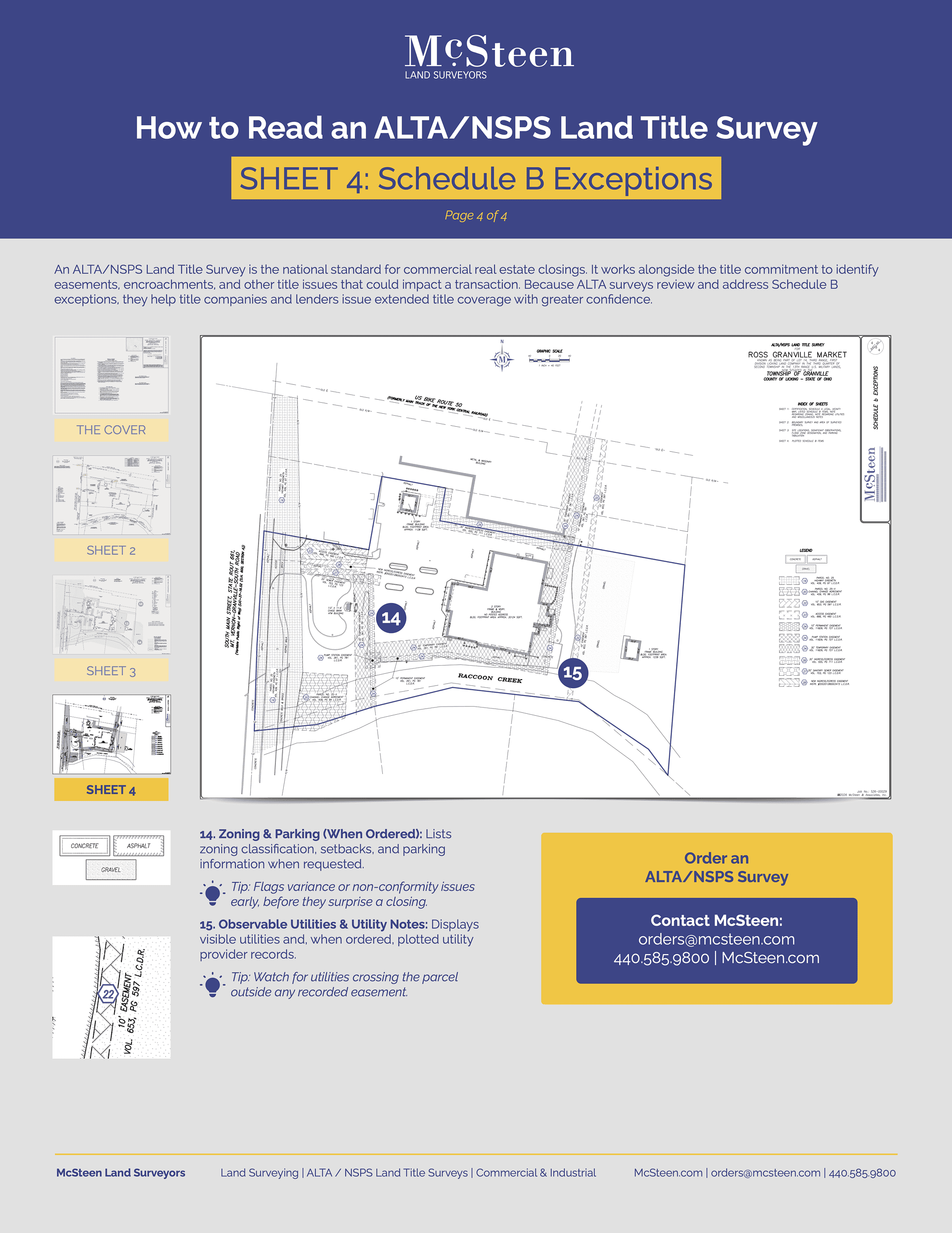
Many professionals assume Schedule B information only appears on the cover sheet. In reality, additional survey information often appears throughout the drawing. Examples include:
Zoning and Parking Information
When requested through Table A, zoning classifications, setbacks, and parking information help identify potential compliance concerns before closing.
Observable Utilities
Visible utilities—and, when ordered, plotted utility records—help identify whether utility lines cross the property outside recorded easements.
These observations may reveal issues that deserve additional review before development or financing proceeds.
Why Understanding an ALTA Survey Matters
Every commercial real estate transaction carries risk.
Understanding what an ALTA/NSPS Land Title Survey is communicating allows title companies, lenders, attorneys, developers, and buyers to identify concerns early rather than discovering them after closing.
A careful review can help uncover:
- Boundary discrepancies
- Easement conflicts
- Encroachments
- Access concerns
- Flood risks
- Utility conflicts
- Zoning considerations
- Title exceptions requiring further investigation
The earlier these items are identified, the smoother the transaction can move toward closing.
Partner with McSteen for Commercial Land Surveys
At McSteen, we know an ALTA survey is more than a requirement for closing. It’s a tool that helps title professionals, lenders, attorneys, developers, and property owners make informed decisions with confidence.
That’s why we believe our responsibility extends beyond delivering an accurate survey. We believe in delivering an exceptional client experience built on trust, responsiveness, innovation, and clear communication. The McSteen Standard promises our team will create confidence throughout the transaction, from the moment an order is placed until the final survey is delivered.
Whether we’re completing a complex ALTA survey, a Boundary Survey, a Mortgage Location or Surveyor Location Report, our commitment remains the same: combine experienced professionals, innovative technology, and responsive customer service to help keep your project moving forward. We don’t just hand over a piece of paper; we put heart and soul into every project.
If you have questions about an upcoming ALTA survey or simply want a partner who values communication as much as precision, our team is here to help. Contact McSteen today to request a quote or learn how we can support your next commercial real estate transaction.
Related Articles:
The Ultimate Guide to ALTA Surveys
Which Do You Need? Commercial Boundary Survey or ALTA Survey?